
A comprehensive collection of the best places to hike in Oregon could fill several volumes – in fact, guidebooks are often broken down by region to avoid overly cumbersome tomes. From the Pacific coastline to the Wallowa Mountains, from the Columbia Gorge to Crater Lake, from the Cascade Range to Central Oregon’s High Desert, there are stunning landscapes to be found throughout the state. So to keep this list manageable, we’re going to keep this to day hikes with difficulty levels from easy to moderate. Still, choosing just 11 was a challenge…
Advertisement
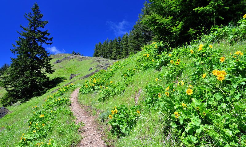
11. Tire Mountain
Love flowers? Then hiking Tire Mountain is a must. This trail, in the Willamette Valley foothills about an hour outside Eugene, is an easy 7.6 mile roundtrip hike, with all but the last mile featuring a gentle climb in elevation. It begins with a half mile walk through the forest before opening to the first of two small wildflower meadows. Despite the trail ending in a clearing that once housed a fire lookout, much of that view is obscured, so take time here to admire the view of the Hills Creek Reservoir and the mountains beyond. Continue on past another small meadow, admiring the various types of wildflowers, before emerging at the last, largest meadow carpeted in tiny pink flowers. It’s fine to stop here, but continuing on into the old growth forest will provide a chance for some solitude – this trail is almost never crowded – amid a beautiful backdrop.
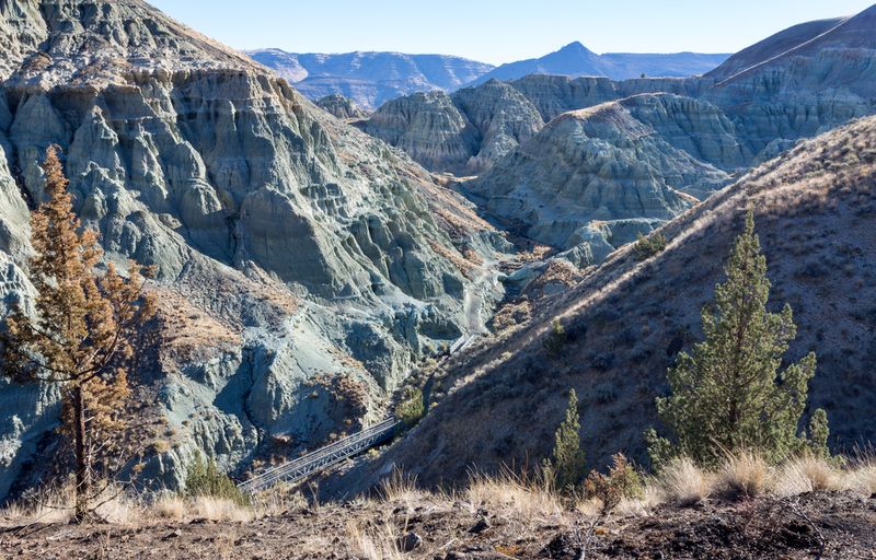
10. Blue Basin at Sheep Rock
The Painted Hills, located in the John Day Fossil Beds National Monument in east-central Oregon, provide one of the most beautiful natural landscapes in Oregon. But with hikes extending barely more than a half-mile, hikers should admire the hills then plunge deeper into the monument, heading east for Sheep Rock Unit. There, the Blue Basin provides a landscape appropriately far removed from the lush green forests and clear blue streams of western Oregon. The 3.25 mile loop takes hikers on a steep climb through bluish green rock formations, past juniper trees and sagebrush. The lookout, 700 feet up, provides visitors the chance to look down at the many geological layers on display throughout the surrounding hills and mountains. The interpretive markers placed along the trail help make sense out of both the geology and fossils surrounding the area, painting a picture of a trip way back in time.
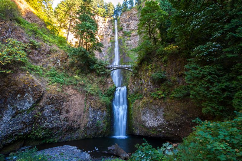
9. Multnomah Falls and Beyond
Oregon’s mountains feature plenty of gushing cascades and picturesque trickles, and many of these gorgeous waterfalls can be viewed after little more exertion than a short stroll from the car. In fact, the sheer drop of Multnomah Falls itself doesn’t require a trek at all. So why bother with 5 miles of steep slopes? Well, in addition to fresh air and healthful exercise, this loop brings hikers up and across the distinctive bridge separating Upper and Lower Multnomah Falls (mind the tourists snapping photos), then on through past 10 waterfalls in total. In addition to beauties like Fairy Falls, which tumbles gracefully in its fan-like formation, hikers will also be treated to several lovely viewpoints above the Colombia River. Take care to stop at Multnomah Falls’ Upper Viewpoint – it may be crowded but the views from the top of the falls make the sight a must-see.
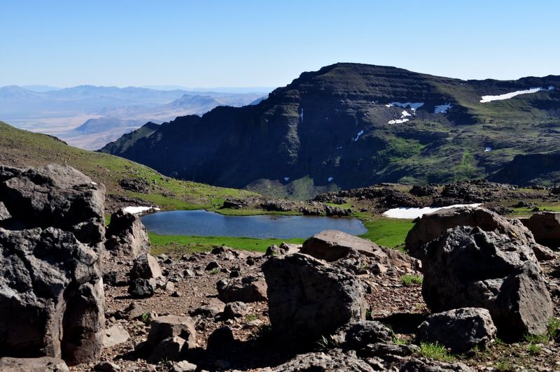
8. Wildhorse Lake
Steens Mountain is one of the more popular hiking destinations in Southeast Oregon, but this trail beneath the mountain’s summit transports hikers into a wilderness that feels far, far away. Yet this hike is just 2.5 miles roundtrip, descending from the easily-accessible overlook down an admittedly steep path. It’s worth picking through the rocky way, however, following a little stream to gorgeous meadows filled with white and yellow, pink and purple wildflowers. The lake itself seems to hover above the treeless valley floor, spreading out like a puddle and reflecting the cliffs above. Stay awhile to bask in the almost otherworldly atmosphere before tackling the tough trek back up. For those with energy to burn, the Steens Summit Trail provides a short climb from where the Wildhorse Lake trail descends, offering breathtaking views that, on a clear day, cross state lines to California’s Mt. Shasta.
Advertisement
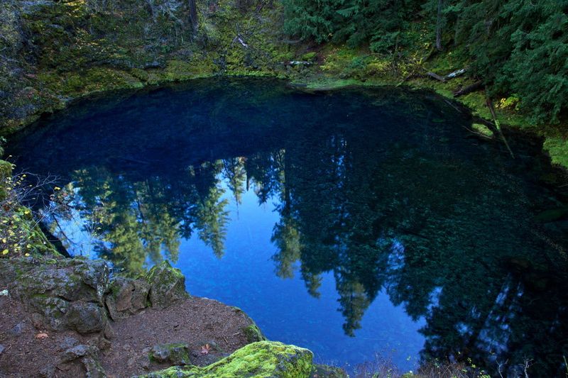
7. McKenzie River
This trail is well known as one of the best mountain biking areas in the U.S., but hikers should add it to their list as well. Altogether 26 miles long, a rather more approachable trip for day hikers is to set off for a 4 mile hike to Tamolitch Pool. Also known as Blue Pool, this is where the McKenzie River slips back up through ancient lava flows after spending several miles flowing underground. As the name suggests, this pool is a stunning shade of turquoise, made all the more surprising by it appearing as if from nowhere. The water is so clear that it looks to be only a few feet deep, but is in fact deep enough that adrenaline junkies get their fix by cliff jumping from the surrounding rocks. Just know the water is ice cold, even in the depths of summer!
6. Bonny Lakes
The Wallowa Mountains are one of the most beautiful mountain ranges in the United States, with wildflower meadows hiding amongst snowcapped peaks giving this northeastern corner of Oregon the nickname “Little Switzerland.” The bad news about the Wallowas is their inaccessibility means the best hikes are often backpacking trips, with the shorter trails feeling crowded due to the ease with which they’re reached by car. Bonny Lakes, however, gives a great glimpse of the beauty of the Eagle Cap Wilderness Area while still offering solitude. This moderate hike, best done in late summer, is 7.8 miles along a glaciated canyon, showcasing two alpine lakes at its peak. From the basalt benches to the rushing creeks to the wet meadows, there’s plenty of diversity along the trail. Those wanting wildflowers should head up in mid-August, when the lilies, purple monkhead and pink wild onion are at their most lovely.
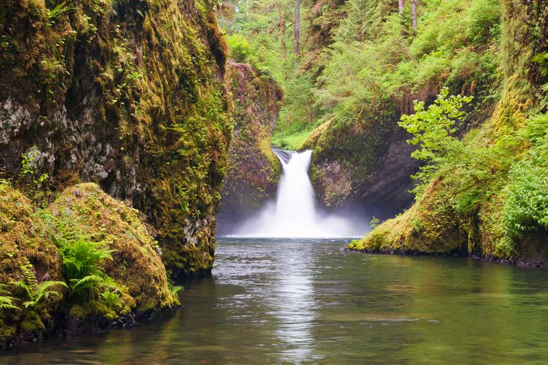
5. Eagle Creek
The Colombia Gorge is stuffed with waterfalls, so much so that almost any trail chosen will lead hikers to a hidden cascade. Yet the Eagle Creek trail is one of the most popular in Oregon, with the first two miles of this 12 mile hike quite crowded in the summer months. Many of those visitors are heading for one of the most beautiful sights in the state: Punchbowl Falls, a 36 foot cascade spilling into a stunning blue pool. Those not afraid of heights should continue on, braving the High Bridge and the path carved into the rock 120 feet above the ground. The ultimate reward comes after six miles, where the path turns to reveal the stunning 175 foot Tunnel Falls. About midway up its span, the trail passes through a tunnel behind the falls, providing a unique opportunity to get up close and personal with the spray.
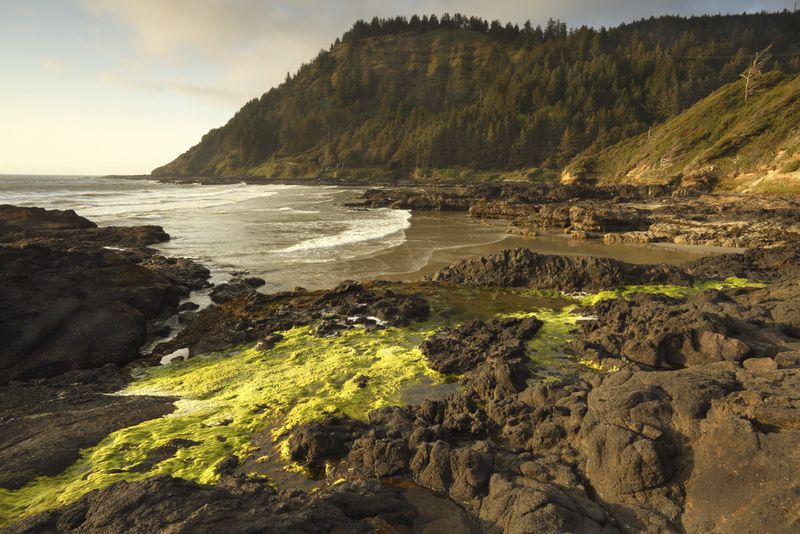
4. Cape Perpetua
Located 3 miles south of Yachats on the central Oregon coast, the Cape Perpetua headland is crisscrossed with nine trails, from easy paved walks to the tidal pools to more challenging hikes through the forest. The Saint Perpetua Trail, too, can be extremely simple, for those that park at the nearby Whispering Spruce trailhead and walk the quarter-mile loop. A greater challenge is completing the full 1.5 miles on the longer trail, including the 700 feet climb to the path’s true reward: the stone shelter built in 1934 by the Civilian Conservation Corps. This beautifully constructed viewpoint provides unparalleled views of the coastline and the Pacific Ocean, and even allows the opportunity to search the horizon for spouting whales. A word of caution, however: the Oregon Coast is often “socked in”, or enshrouded in fog, even when it’s sunny inland, so plan accordingly.
3. Mount Hood
Oregonians use their own vernacular when talking about the weather. To signal a sunny, clear day, those in the upper Willamette Valley will often say, “The mountain is out.” This means the near-perfect triangular form of Mount Hood, the tallest mountain in the state at 11,249 feet, is brilliantly showcased against a bright blue sky. But while the mountain looks spectacular looming above the Portland city skyline, the best views of Mount Hood require a bit of physical exertion. Take the Vista Ridge Trail for easy access to the Timberline Trail, where the first great views of the mountain can be seen. Persevere onwards and upwards, through the peaceful Wy’East Basin and past meadows dotted with wildflowers, until the trail turns sharply. There the mountain towers over ancient forests and rocky cliffs, providing an incomparable vista to those seen from the valley floor.

Advertisement
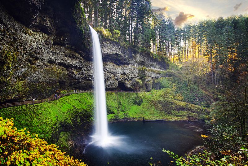
2. Silver Falls
It’s not necessary to walk all 8.7 miles of the Trail of Ten Falls to get a feel for the beauty that is Silver Falls State Park, but those that do stick out this moderately challenging hike will be amply rewarded. This popular trail includes, as its name suggests, visits to ten waterfalls. The popular South Falls ends the loop, with a cave behind for crowds to look out from behind the water. But there are other such grottoes along this trail, including the magnificent view from the large cave behind North Falls, which offers a glimpse from the spray out into the deep green forest beyond. North Falls provides a steep, thundering wall of water, but the tallest on the loop is Double Falls, plunging 178 feet in two tiers. This trail is best hiked in spring, when winter runoff ensures the waterfalls will be at their most dramatic.
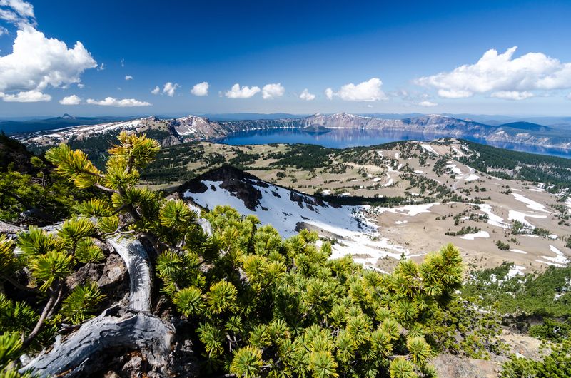
1. Mount Scott
Crater Lake National Park makes for a postcard perfect view from every angle, but it’s said that the only place a camera can capture its full circumference is from the summit of Mount Scott. The lake, which sits inside a deep caldera formed by a collapsed volcano, is astonishingly blue, reflecting the clouds above and the peaks around its edge. On a clear day, the view also extends from Mount Shasta to the Three Sisters, overlooking the Klamath Basin. Despite the 1,245 feet of climb, this is an easy 4.4 mile hike that families regularly undertake together. Take note: Because the trail begins so high up, it often doesn’t open until late July, but that’s fine because that’s also the best time to see the alpine flowers in full bloom along the path. Still, be sure to take a sweater, as the summit is often cold even in late summer.
Advertisement